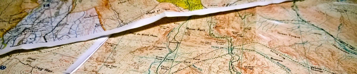
A growing repository of resources, tips and downloads about Google Earth and digital mapping for expedition planning. Please send suggestions and corrections by email to me.
Mapping for Expeditions
Resources, links, downloads, guides
Browse OS Maps (UK) online
You can access 1:25k and 1:50k mapping for the entire country, for free, using with Bing Maps or Streetmap as your mapping search engine (as opposed to Google Maps).
- bing.com/maps
Key benefits: easy to use interface and search engine, quick to pan across country, large viewport
Disadvantages: maps are re-projected such that grid lines are no longer parallel - streetmap.co.uk
Key benefits: map grid is correctly aligned to pixels and not skewed, has extra detail (e.g. crag names) in some locations if you zoom further
Disadvantages: site feels like it was built in 1999
Ordnance Survey themselves have an impressive set of digital products these days:
- Digital + paper maps
As of May 2015, Ordnance Survey will supply a digital map with every paper copy of the map purchased - OS Maps Online
Subscription service to view and print maps from a computer - OS Openspace API
Developer service to write apps and websites using OS data - OS Route planning tool
Very useful contour+path maps of the country for route recording
Many other websites make use of the API mentioned above to provide OS maps for free, for instance wheresthepath.co.uk (side-by-side comparison between OS maps and satellite imagery) and http://maps.the-hug.net/
For historical mapping, the National Library of Scotland have an excellent collection of maps to explore on their website.
You can view mapping data online for other countries here:
- Austria (click "Show Map" in top right)
- France
- Iceland
- Italy (south Tirol)
- New Zealand
- Norway
- Norway (alternative)
- Spain
- Slovakia
- Switzerland
- Switzerland (alternative)
- United States
Simon Likes Maps, run by Simon Freytag, is an easy to use interface to create route maps all over the world. The site combines many of the sources above into a single interface.
Google Earth vs. Google Maps
Google produce two of the best tools for exploring the world: Google Maps and Google Earth.
- Google Maps
Launched in 2005. You can only access this location when you have an internet connection: the speed with which you can explore the world is largely limited by the capabilities of your web browser. Google Maps allows you to collaborate on annotated maps (markers, lines etc) with others (click in the search box and select “My Maps”). - Google Earth
Launched in 2001. Prior to 2015 there was a free and paid for “Pro” version but both are now free (so you may as well download the best one)! This is a separate program you download and install onto your computer. It combines two sets of data: a digital elevation model of the earth and digital satellite imagery taken over a period of many years.
Navigation
You only need three buttons to navigate Google Earth. A proper three-button mouse is essential.
- Left mouse button
Click and drag to pan around the world - Middle mouse button
Click and hold to spin the world in 3D on the spot - N key
Press to rotate the view back to north at the top (an indispensible tip!)
You should go to Tools > Options and under the Navigation tab select Do not automatically tilt while zooming.
Google Earth tips and tricks
You can download a cheat sheet of basic Google Earth commands.
Some useful tips and tricks for mountaineers:
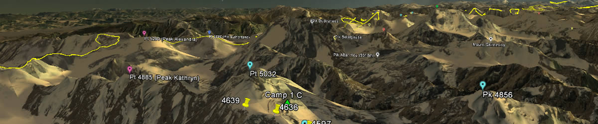
- Elevation profiles along a route
After drawing a route, right click on the route and selectShow Elevation Profile - Sunlight and shade
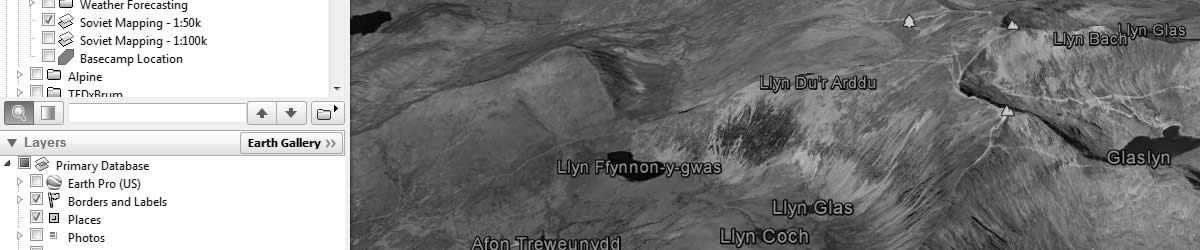
The menu buttonShow sunlight across the landscapesimulates shadow location at a given location for a given time of year. Adjust the date to the planned date of your trip and see if the face or basecamp will be in shade or not. - Photos of locations
Make sure thePhotoscheckbox is ticked in theLayersbox to place tiny markers onto the map with geo-tagged images from the web, primarily Panoramio. Particularly useful for location photographs from trekking and climbing parties in the region of interest. - Photos of locations
TheShow historical imagerymenu button presents alternative, dated satellite images of a location. Good for giving an indication of likely snow or serac cover.
Good datasets worth downloading:
- UKClimbing database
UKC database of all crags on record, with links to their respective pages - Google, Bing, Yahoo map overlays
An overlay of the Google, Bing, Yahoo and OpenStreetMap mapping tiles. Good for seeing alternative satellite imagery, or terrain-only views. - KML dataset generator
Website for generating KML datasets from alternative sources to Google Earth (e.g. USGS data for the USA). - Landsat-8 up to date imagery
A little more advanced, but a good guide on importing the latest Landsat imagery into Google Earth.
More information and resources can be found on the old Google Earth forums. The GPSVisualiser website includes some useful tools for converting GPS data into Google Earth files and making a Google Map from a GPS file.
Using maps for expedition planning
A good general introduction to using online maps to plan expeditions can be found in the UKClimbing article: "Where on (Google) Earth?". There is also a shorter summary of the information on this page in article I wrote the BMC: Using free online mapping for expedition planning.
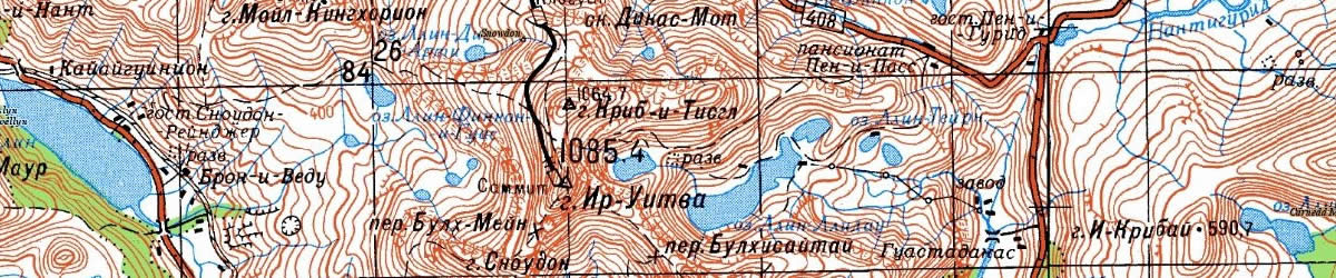
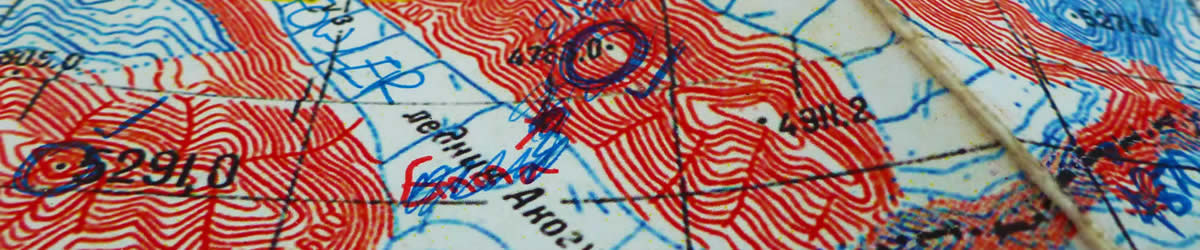
Many climbers make use of old Soviet maps on their expeditions. The number one resource for these is: http://loadmap.net/.
Maps can be downloaded individually by clicking through on a file of the appropriate scale. Most extensive coverage is of central Asia where many areas are mapped to 1:50k resolution, however 1:100k or 1:200k resolution maps exist for large parts of the world.
If you wish to pay for some maps (!) and purchase an entire country in one go, there are number of sites on the internet including http://mapstor.com/.
Other useful tips and links for using Soviet maps:
- Adding a GPS grid overlay
A very useful guide by John Proctor covering one method of drawing GPS grid datum lines onto the Soviet maps - WIRED: Inside the Secret World of Russia’s Cold War Mapmakers
Fascinating WIRED article about the history of the maps - Soviet Military Topographic Mapping
Good collection of links about the maps from a non-climbing perspective - Uncle Joe knew where you lived
Excellent article from the The Charles Close Society about the history of Soviet maps - Geographie (French)
A rather random collection of many different maps from central Asia, including many Soviet maps. - Pahar Mountains of Central Asia
Downloadable maps by country, patchy coverage.
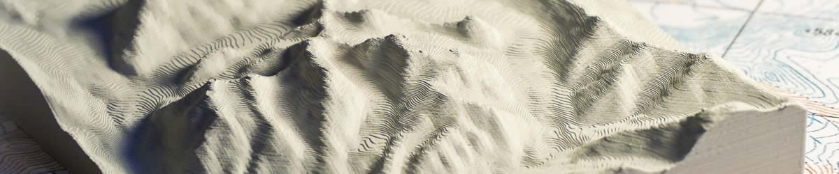
3D Printed Models
Recently I've been exploring the idea of 3D printing models of mountain ranges. Some useful resources to help with this process:
- Terrain2STL
My favourite website for downloading a 3D STL of a certain region. - Thingiverse - Yosemite Valley, Half dome, and El Capitan
Thingiverse has a small set of pre-generated 3d topos to print, like this one. Handy if you just want to print a popular location. - instructables guide to 3D printing a model
If you've no idea what to do, this takes you through it step-by-step, but the method they list isn't the most straight forward. - Nice Trails
Company who will create 3D printed models of your routes.
More resources
Apps:
- Multiplans App
Offline browsing of any map file you have (that is georeferenced). Might work with Soviet maps? [untested]. - Alpine Quest App
Looks similar to Multiplans App [untested]. - Maps.me
Offline maps for your travels. - Soviet Military Maps App
Android device app containing lots of the Soviet military maps [untested].
Software:
- MAPC2MAPC
Small software package which will crop and adjust maps from one format to another. Useful for removing the white margins around the Soviet mapping sheets and aligning the edges to be perfectly square. - Nearby.org.uk
Collection of utilities for working with location data and Google Earth KML datasets. - OziExplorer
Piece of software to work with the Soviet maps (amongst others) and their accompanying .map files [untested]. - ImageMagick Perspective commands
For the programmers, you can use ImageMagick to write a script which will perform the require perspective distrotion of the Soviet maps to fix the mis-alignment.
Trackers and hardware:
- Garmin GPS guide
A very good guide to using the Garmin GPS devices which includes an excellent technical overview of how mapping datums and origins work and what they actually mean. - Alpine Club: Electronics and Gizmos
Summary by John Town on the AC Expedition Information Centre of the different bits of kit available for navigating in the mountains. - Hacking SPOT trackers
A rather nerdy (and therefore very interesting) explanation of how to send extra data over the SPOT network.
Commercial services:
- Tile Server
High speed hosting for your maps - Map Tiler
Prepare and publish your own zoomable maps - Mapyx Limited
Tracking for events like DofE - Open Tracking
Event tracking powered by OS Openspace
Fun map things
Interesting links for real enthusiasts:
- The True Size Of...
Mapping projections can be very misleading and our understanding of the relative size of countries isn't very intuitive. A superb interactive demonstration of this. - OpenStreetView
OpenStreetMap now has OpenStreetView! - SRTM Dataset and information
Lots of information and downloads on the Shuttle Radar Topography Mission which gathered the relief data used in Google Earth. - Viewfinder Panoramas
Collection of data sets and technical information around elevation models of the world, including panorama data from many different peaks. - Geograph
An interesting project to collect photographs of every 1km grid square of the UK. - Make Panoramas
Incredible website to generate skyline panoramas of any point based upon relief data.
In 2013 I had the chance to speak at TEDxBrum (Birmingham) about using digital maps to look for unclimbed peaks. The talk is embedded below:
Disposing of maps
Finally, you can make use of trailmix pieces to play chess on an un-wanted 8x8 section of a Soviet map. Other maps might work too. Recommended to tape down the corners and to make a list of which piece is which. Upon capture of a piece, you may eat it.

